(August 2020)
Far from basking in the glory of completing an epic 3-day journey around some of the most beautiful backcountry our state has to offer, I am left to wonder – Why? I’ll try and explain my thoughts – and they likely will seem harsh to many in the ultrarunning community, but remember the source – a middle age, middle of the pack athlete trying to get the most enjoyment from his time outdoors.
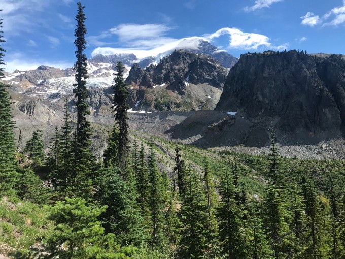
First, an introduction. The Wonderland Trail is a 93 mile continuous trek around Mt. Rainier. Camps dot the trail every 6-8 miles or so. There are major rivers which must be traversed and a variety of bridges have been engineered to keep you from plunging into the icy, glacial runoff. The main park visitor hubs – Sunrise, Longmire, and Paradise are close by if needed but once you get a few hours hike away from these hubs, the traffic disperses – i.e. there aren’t too many people roaming about here. It is wild.
Having seen many friends tackle the Wonderland in a day, I seriously considered how this would be possible. Returning back to reality, I elected instead to sign up with an organization which specializes in outdoor treks (Aspire Adventures) and let them carry my camping gear and clothes around as well as provide food for morning and evening. Their plan involved splitting the circumnavigation into three mostly equal sections. They had 5-6 weeks in August – September, with the adventures beginning Thursday morning and ending on Saturday. All I needed to do was get up, get dressed, and focus on the destination for that day. After sharing some basic profiling information and mostly adering to their training plan I was ready. We met on a Wednesday afternoon down in Ashford, WA just outside the Nisqually (southwest) entrance and moved over to a campground outside the park to set up for the night and make final preparations.
There were 6 runners and 3 highly capable staff members to keep us motivated, energized, and informed. We shared notes and strategized some, but this first night was mostly about getting to know each other. The idea was that we would all have different skill levels and would mostly be on our own. There was to be one sweeper at the back of the line to make sure everyone made it through. GPS phones were available in case emergency situations arose. We would be splitting the 93 miles into 3 roughly equivalent sections. Each would have 7,000 – 9,000 feet of gain (and loss). We would have about 14 hours of daylight to work with, but brought headlamps just in case. Aspire did a gear check before we started to make sure we were well prepared for wilderness conditions.
Day 1: West Wonderland
We all broke camp at the same time, drove into the Mt. Rainier National Park and nervously gathered all our belongings for what would be three days away from the normal mechanics of our lives. We took the obligatory group photo by the Wonderland sign at Longmire and headed out. The first day was going to be the hardest as it was longest and had the most climb. Off we went.
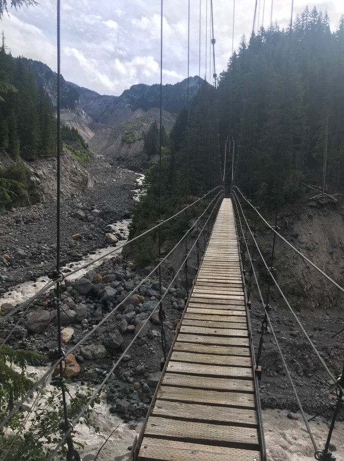
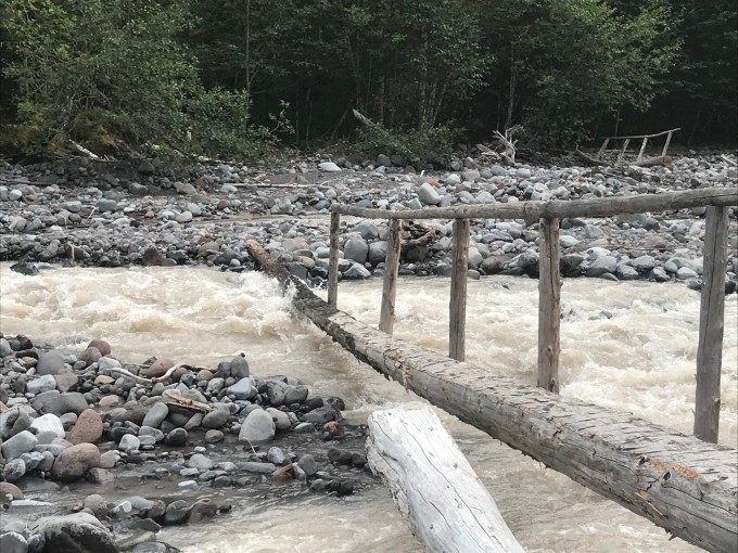
There actually was a short stretch of runnable trail at around mile 3, but both the grade and terrain made it difficult to get much momentum, so I pushed forward as best I could. We made it to the first meadow at Indian Henry which was flush with wildflowers. Awaiting us below was the Tahoma Suspension Bridge, a beautiful structure perhaps 100 feet above the roaring river below. As you neared, it suddenly looked more like a weekend project with metal cords purchased at the local Home Depot. We carefully crossed one at a time – I believe I was just behind the first couple runners at this point. The general rule for the day was – down to a river crossing, over the river, and then climb to a vista. The push began as we moved higher and edged closer to a different geological strata. At mile 10 we popped out onto Emerald Ridge, almost moon like in its surroundings and began making our way down to the river. There were 5 climbs and 4 descents in the day and I was hoping I could enjoy some fun downhill along the way.
It was not to be. The downhills were almost tougher than the uphill – each step required careful consideration to avoid tripping or shredding your ankles. Miles after miles – we made it up to an alpine lake setting at St. Andrews but the bugs chased me away and I continued onto another long winding stretch down to the North Puyallup river, a crossing, and then back up another 3-4 miles and 2000 feet up on our fourth climb of the day. I was taking in calories sparingly but also drinking lots. It was important to find streams to filter water every few hours, and on this side of the mountain it was pretty easy.
The climb up to Golden Lakes confirmed what we all knew going in – it was going to be a hard day. It wasn’t really possible to get any momentum on the climbs due to both the grade of the pitch (10-15%) and the terrain itself. The trailblazers had even installed numerous switchbacks – trails which zigzag left to right to lessen the steepness of the climb – but they became repetitive as well. So the strategy became a head-game – keep pushing ahead and with every step get closer. I had some decent tunes on and was able to stay in a good frame of mind the whole way up. Apparently I missed the bear sighting that others experienced just both before and after me. On leaving the Golden Lakes area which actually had a mile or two of runnable trail – not too steep down, dodging roots and rocks. I did have my first and only tumble of the day making my way down to the South Mowich River and landed on a small tree knob, but after a moment’s whimpering and realizing that no one was going to dust me off, I got back up and found the river. Now, to cross.
One of our guides, Ian, had stopped me a few hundred yards up to explain the crossing, but he gave way too many instructions. I heard “ribbons on the right, cross, then veer back to the left”. OK. Lance, a Portland based actuary (!) had caught up with me and we began deciphering the instructions. The ribbons were obvious and we followed them for awhile but still not too obvious as there was a narrow log bridge without a hand rail for 10 yards with water rushing over it to the left and then a huge log off to the right with no obvious path to it. I chose to crawl across the log – yes on all fours – as the cold water rushed across my hands. Of course by then with 28+ miles on the legs they began cramping up as I tried to maneuver to stand up. (Fortunately no videos were made of this gymnastic attempt). I successfully traversed the bridge but scared Lance so much that he elected to try the other option (which was the correct one).
Now we began our last climb of the day, up to the Mowich campground where our bags, and dinner, awaited us. 4 miles – no problem. It turned into a 2 hour bonkfest, reminiscent of my Cascade Crest 100 attempts. I was low on calories and stubbornly fighting the need to push food down my throat. This is purely an ultrarunner malady and not something normal people understand. Anyhow, I weakly ambled up to the lake and finished my day in roughly 12 1/2 hours – about 3/4 of it enjoyed with the last stretch not so much fun. It was turning dark as I set my tent up and tried to get some food down because I would need some sort of energy for …
Day 2: North Wonderland
My feet cramped nearly all night, meaning I got very little sleep. Still, after getting up and doing some mundane activity, I could tell I was going to be OK leaving the gate. The course on day 2 would take me on familiar grounds – up to Spray Park (about 2000 feet in 4 miles) down to the Carbon River and another suspension bridge, up up to Mystic River and then eventually poke out into the Sunrise area, where crowds throng. It was an overcast cool morning and I knew it could get colder up at higher altitudes so made sure to pack gloves, a rain jacket and a windbreaker. I would need all three.
It turns out Ian is also a cook up in Bellingham during the week and he made an absolute top-tier breakfast burrito for us – just bacon, eggs, and hash brown but yum! I *never* eat before running, but knew a) I badly needed calories and b) we weren’t running, we were hiking. After getting all my gear loaded back into my duffel bag and placing it near the Aspire truck, I headed out about 8:00am – I liked the idea of starting whenever you were ready. Ram, a friend of mine from our health club in Bellevue who just happened to sign up for the same trip (!) caught up with me, and we chatted some. This really helps to pass the time, especially on climbs. He was stronger than I at the vertical and moved a hundred yards or so ahead, as did another member of our group. This was actually helpful as I could watch them traverse the dozens/hundreds of steps which lead up to Spray Pass. Sadly the bears were still avoiding me – this is a common hangout area for families. Once you reach the summit you are greeted by meadows of wildflowers, more steps, and eventually some large snow patches across the trail which need to be crossed. I should say that by the end of Day 1 I had switched over to using my trekking poles, like everyone else, and they really helped with the snow patches.

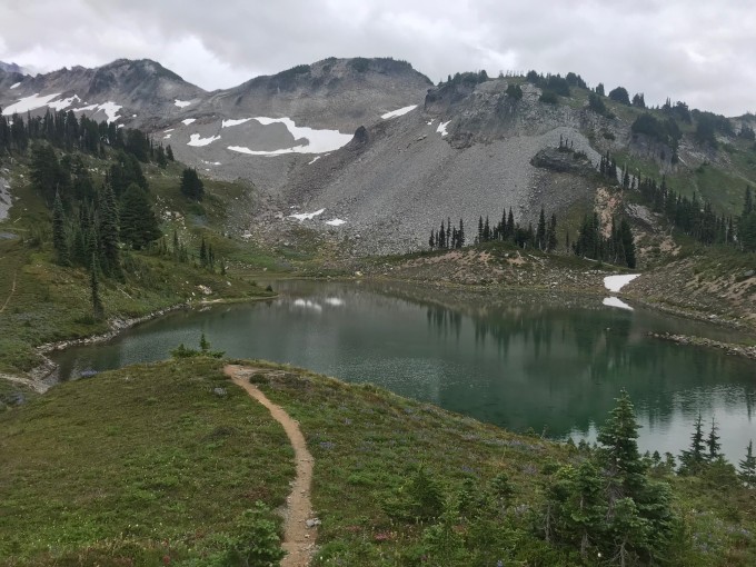
I was trying to remember if the path down to the Carbon River was runnable and it turns out it really isn’t. So by the time we hit the torrential water and bridge, we were at about 3.5 – 4 hours into our day with only about 8 miles completed. It turns out that’s the pace you can achieve when hiking. I remembered the climb back up to Mystic River as my son Carter and I had done it two years ago. It started very steep up to Dick’s Creek and then after a few miles moved into the meadows of Moraine Park. There were a few hikers out on the trail – everyone responsibly wearing masks. I got past Ram and caught up with another of our runners, Gerald as we hit Mystic Lake, which is a nice quiet place to rest – about halfway into the day. We dipped our toes into the lake a few times, just as the rain began to pick up. We were now roughly halfway into our 26+ mile day at 2:00pm.
We then had our last big climb of the day up past Granite Creek. This one goes on forever and is mostly covered forest for a few miles. I’m not sure I saw anyone for over an hour. Again, the grade was way too steep to get any type of trot going. It was nice, however, to hear the creek off to the left as I worked my way up and punched through the upper sections and into the open, north side of the Wonderland. Despite its popularity there was not a soul in sight which was very strange. Still, I was elated because this was runnable trail – I took off and got a few good miles running across the undulating hills and peaks. The Burroughs mountains (actually three separate peaks) were off to the right but all covered with clouds. I decided to do some bonus miles and headed over to Sourdough Ridge – technically not part of the Wonderland but it would loop me around to Sunrise Visitor Center and then connect again with the Wonderland.
By now, it was starting to rain reasonably hard vs. the mist we’d experienced most of the day. I had switched over to my rain jacket earlier and the exposure and altitude equated to stronger winds and much colder temps. Within the last 30 minutes the temperature had dropped 10+ degrees and suddenly I was chilled and soaked! Not good. I headed into the Visitor Center to dry off and switched over to my windbreaker and grabbed my gloves. It was less then a mile to begin a huge descent (2000 feet over 2.6 miles) down to the large White River camp site where we would spend the night. Sure enough, within 15 minutes I was warm again as I sped up to find my friend Ram again, explaining my voluntary detour. We got down to the site in no time at all – it was a very tight squeeze to get all 9 of us into the group area but we managed. Ian was making burgers and they hit the spot. It was still dripping rain and we heard the constant roar of the powerful White River just yards away as we shared stories of our adventures and transitioned to prepare for
Day 3: East and South Wonderland
The rain had finally stopped in the middle of the night and we all woke bright and early with the dawn. It was the day to close things out and finish the loop. I had woken in the middle of the night with a hotspot on my right foot. I’d had blisters before but nothing this painful. Fortunately, I had my medical bag and Neosporin and a patch covered it up. Finding dry socks took a bit longer than it should have. The forecast was for warmer weather and sun – great for views but dangerous for overexertion. I poured some Gatorade powder in my water pouch. Breakfast, my new best friend, was a sausage-egg muffin. Lance and I headed out at 7am promptly.
I had done the climb up to Summerland in late July and so knew that much of it was runnable. Indeed we made good time getting up the 6-7 miles to the group hut and then veered off towards Panhandle Gap. This was to be the highlight of the trip – the skies were clearing and while the climbing was difficult it was all right in front of you – up and down – many steps and rocks to climb over. From a distance I could see Lance and Ian, who was our sweeper for the day moving along the trail. It helped tremendously to know what the next challenges would be. We had a bit of snow to sidestep going through the gap but overall it was an easy passing. I gasped looking up at the next peak, wondering if we needed to tackle that as well – other hikers were heading up. Ian assured me the Wonderland headed down to Indian Bar.


As we veered to the side we began going down switchbacks galore and suddenly the trail narrowed to a minimal 12 inches with wood bar steps across. It was crazy hard to go down. This went on for easily half a mile and I was dreading that this would continue all the way down but suddenly it stopped and we saw a beautiful creek with many of the team members filling their water bottles. Indian Bar was a welcome sight. The next few miles we went up and down over “bumps” with fields flush with wildflowers surrounding us. It was exhausting and exhilarating at the same time. And then just like that we plummeted into forests and headed down to Nickel Creek on a runnable trail. 10 minutes, 15 minutes, I kept waiting for the rocks to appear but we had a good 30 minutes of downhill carpeted trail to stretch our legs on. Eventually I reached Box Canyon which is a narrow passage way with an east-west road cutting through it. Aspire had set up a true aid station (our only one in 3 days) with grapes, watermelon, cookies, and drinks. Lance and I hung out on the wall for 5 minutes or so, reflecting on the wonders of where we had been. We were 19 miles in, with only 12 to go.

After walking through a tunnel we found the Wonderland trail head and jumped into the land known as Stevens Canyon. It was more runnable downhill for a mile or so and then easy going as we accompanied a river for quite a while. Lance had taken off which was fine, but the signage for the climb up to Reflection Lakes had stopped and I made my best guess on where the Wonderland continued. The Gaia app on my phone, my true savior, was not working well because the rain from the day before had waterlogged my screen protector – I could load the app but the button to show my current location as compared to the Wonderland color route (GPX) pre-loaded was not working. I finally found a couple heading down from the Lakes so I knew I was going the right way. The trail had seemed too easy – i.e. the grade was not steep enough. That changed almost immediately. There was even a landslide area which was a bit sketchy to tiptoe around – an easy place to fall a long way down. It was the last climb and I was enjoying it in part because a breeze was picking up and cooling me off. I wasn’t doing well on food intake but knew I could “wing it” the last hour or two, mostly downhill. As we neared the top, Ian and Monica, another runner in the group caught up with me just as we reached the road which led to Reflection Lakes, a popular family gathering place on the south side of the park.
While they cooled their feet off in the lake I continued on, counting down the miles and beginning my reflection on the overall adventure. Rainier has many breathtaking vistas and the openness in certain areas leads to stunning views for miles. The ability to get so close to active glaciers is amazing – hearing the rocks grind and break off is startling. The power of the rivers is intense and needs to be respected. The bridges that we traversed were in various stages of stability – many need replaced monthly. But certainly one of the more striking points to take in is the sheer remoteness of the park. Despite huge amounts of traffic into the region daily, it was easy to go hours without seeing another soul.
My biggest personal takeaway was to do better at respecting the contour of the trails. Yes, there are warriors out there that can run much of the Wonderland. I have never been nor will ever be that person. This is a hiker’s paradise and while I might bemoan the narrowness of the trail, the number of wooden steps to hurdle over, rocks strewn randomly almost begging you to trip and certainly causing blisters, I needed to literally ground myself. It occurred to me that I was stretching the use of the trail in a way that wasn’t intended. The simple reason I love going faster is so I can see more in a fixed amount of time. But some journeys reward a more methodical study. And so it should be.
I finished day 3 in about 11 1/2 hours and joined the others in a celebratory picnic at the lodge at Longmire where we had started our journey 3 days earlier. Our trek was equally difficult and incredible. And in a year where races aren’t happening, it was nice to get out in a semi-organized event, without an official time clock, but with others who share the same passions and obstacles.