With travel somewhat restricted and a summer of adventures behind me, I was searching for a new vista. After discussing with my two sons, we agreed to travel down to the parks in southern Utah. I had been there twice in recent years but they were yearning for something different, so we booked some cheap direct flights to Las Vegas and headed down on a Friday afternoon. Springdale, Utah sits just outside of the border of Zion National Park and is a 2 1/2 hour drive – plus an hour added on to move into the Mountain Time Zone
Day 1 (Saturday)
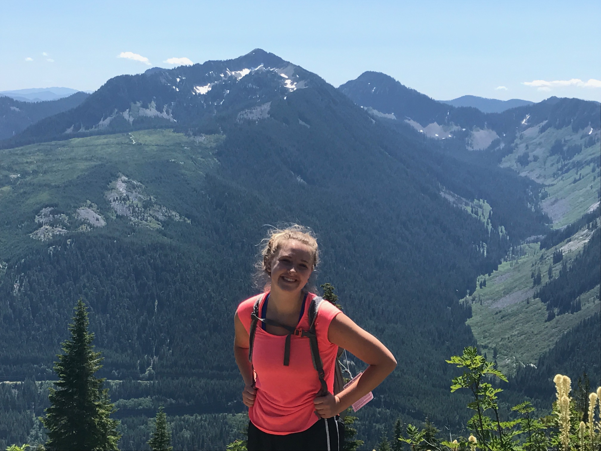
We got out early, grabbed a few munchies and water at the grocery store and headed to the park entrance. After paying the $35 park fee which would last the entire trip we were walking to the shuttle area when we found another line – this one to give you access to the shuttle for day use. This was a new “bumper” put in place (the tickets were $1) to restrict attendance into the park due to COVID. We had no tickets and they were sold out for the day. I suddenly felt like a failure to have missed researching this, but I also had a comprehensive Zion hiking book in hand and knew that there were other options available. We learned how to get tickets for later in the trip and headed over to the trailhead for a shorter hike called Watchmen that does not require the shuttle, and special passes. It’s a great warm up – some uphill but nothing too strenuous. Good views at the top of the canyon. There was a steady stream of people but not too crazy, and nearly all were wearing masks. It served the purpose – to acclimate us to the terrain and warm us up.
We returned to the car about noon and decided to drive to the east side of the park. It was about a 45 min jaunt through the east entrance – like most National Park Service our park pass was good for 7 days – but we got a chance to work our way up to the top to get some amazing views and also get a good layout of the drive. We decided to go all the way to the junction with Hwy 89 and check out a hike called The Barracks. It was easy to find the road down to the trail head but no other cars there and only a camper with a women dressed in very strange and scary Halloween makeup.
We headed off down the canyon towards the Barracks ranch. It was a wide dirt road and easy to traverse. A river flowed along the side. It was quiet, peaceful and serene. Occasionally a car would come one way or the other but we walked out about an hour – 2+ miles – until we reached the ranch. The trail continued on another 10 miles, skirting around the homestead. It was unclear exactly how, but we had seen enough of the area and headed back, birds overhead. Fortunately our car was still there and we began the return trip to Zion.
The Barracks
We still had light in the day for one more hike and so elected to stop just outside the East side park entrance and venture out the East Rim trail. We met a few more people as we worked our way up the slow, gradual climb to the rim. This trail was not quite as wide as the dirt road but gave us enough room to easily bound up the slope. It was about 3 miles when we calculated that we would run out of sun in another hour or so, meaning it was time to turn around. Of course the trip back was a bit easier on the legs. After a brief rest at the hotel, we ventured out to the busy restaurant scene eventually finding room at a Mexican place.
Day 2 (Sunday)
We got an early start on a relatively chilly day and started our drive over to Bryce Canyon. It was about 100 miles between the parks and we made good time, stopping only to grab some munchies in the gift shop once we arrived. It was their last day of operating the shop for the season, so there was little in stock. I had done some research on a couple of new loops and elected to go with Peek-A-Boo, a trail north of the popular Navajo loop. We made good time to go down to the junction – Bryce was in its full glory and we had a beautiful day in front of us.
Bryce Canyon Never Disappoints
Peek-A-Boo constantly is in motion up and down left and right but is reasonably tame overall. The loop itself is about 3-4 miles and took us over an hour to trek. The good news is that the moderate crowds forming in the park in the late morning did not follow us, so we had long stretches of solitude. Most everyone we did see was wearing masks, though there also were some pretty large groups out there.
On our way back to the Rim trail after joining with the Navajo trail we had a nice vertical climb with 10-12 switchbacks which would prepare us well for the following day. As we finished up, the clouds were moving in. Bryce is an amazing layout and the park well managed to get people dispersed across the many trails. We already have ideas for some new trails to explore on the next visit.
Day 3 (Monday)
Having learned our lesson over needing not only park passes but also a day ticket, we got to Zion at our allotted time (7:30-8:00), showed the proof of purchase and boarded the shuttle bus. We were curious to head over to the iconic Angel’s Landing to see how much of it would be open. Only 3 or 4 of the 8 shuttle stops were actually in service with open trails which concentrated the crowds inside the park into a few popular areas. Not good. Angel’s Landing starts with a hefty climb over a few miles – lots of switchbacks. There were people everywhere – it was a carnival atmosphere. Social distancing was incredibly difficult in the reasonably tight asphalt trail as we followed the serpentine path upwards. We poked through into the small cavern and then did the last steep climb to Scout Lookout to survey the situation. The famous harrowing climb to Angel’s Landing was open but there were people all over each other in the tight confines of a very narrow, very steep, very rocky terrain. In other words, it was stupid for it to be open. We didn’t even hesitate to reject that option, despite all wanting to hit the top.
Instead we veered off to the West Rim trail for a 20-30 min effort with good views and very few people. It was definitely the right call. The trip back down to the trailhead was also festoon with people not really paying attention to rules or etiquette of hiking in the pandemic world. It was best to escape. There was some excitement about halfway down as we witnessed a substantial rock slide on the canyon opposite us, maybe 100 yards away. There were probably 10-15 large rocks careening down the side of the canyon smashing against either the side or the floor. It lasted a good 20-30 seconds and scared quite a few.
West Rim Trail in Zion
We did one other hike to the Middle Emerald Pools just to see what these were like. It was also filled with people so we jumped on the shuttle and headed out, arriving at our new favorite diner, Meme’s Cafe, just before a downpour, apparently the first significant rain they’d had since April, six months earlier.
Day 4 (Tuesday)
The day started out a bit strange. We had some extra time to drive to Las Vegas so I went out for a short run in the morning from the hotel towards the park along the main road. As I got closer to the park there were fire engines all about as one of the oldest restaurants in town had burned nearly to the ground over night. Very sad to see.
On the way back, we stopped at two sites. First, Snow Canyon which is just north of St. George and had a very nice 7,400 acre park set aside. It was pretty easy to walk about over the rocks and get some great views. A typical Utah park – very orange and white. Then as we entered into Nevada we ventured off course to explore the Valley of Fire. By mid-day it had climbed to 85 degrees at least and you could feel it in the desert here. We mostly drove about as a) we didn’t have time to do a longer hike and b) it was so hot you would need gallons of water in your pack to survive (as the signs clearly indicated).
Overall, despite the constant requirement to keep our distance from those outside our party, it was still a good way to get out and see some of the most picturesque places in the U.S. Direct flights are a must for me as the time sitting and waiting in the airport seem the most precarious.
Far from basking in the glory of completing an epic 3-day journey around some of the most beautiful backcountry our state has to offer, I am left to wonder – Why? I’ll try and explain my thoughts – and they likely will seem harsh to many in the ultrarunning community, but remember the source – a middle age, middle of the pack athlete trying to get the most enjoyment from his time outdoors.
First, an introduction. The Wonderland Trail is a 93 mile continuous trek around Mt. Rainier. Camps dot the trail every 6-8 miles or so. There are major rivers which must be traversed and a variety of bridges have been engineered to keep you from plunging into the icy, glacial runoff. The main park visitor hubs – Sunrise, Longmire, and Paradise are close by if needed but once you get a few hours hike away from these hubs, the traffic disperses – i.e. there aren’t too many people roaming about here. It is wild.
Having seen many friends tackle the Wonderland in a day, I seriously considered how this would be possible. Returning back to reality, I elected instead to sign up with an organization which specializes in outdoor treks (Aspire Adventures) and let them carry my camping gear and clothes around as well as provide food for morning and evening. Their plan involved splitting the circumnavigation into three mostly equal sections. They had 5-6 weeks in August – September, with the adventures beginning Thursday morning and ending on Saturday. All I needed to do was get up, get dressed, and focus on the destination for that day. After sharing some basic profiling information and mostly adering to their training plan I was ready. We met on a Wednesday afternoon down in Ashford, WA just outside the Nisqually (southwest) entrance and moved over to a campground outside the park to set up for the night and make final preparations.
There were 6 runners and 3 highly capable staff members to keep us motivated, energized, and informed. We shared notes and strategized some, but this first night was mostly about getting to know each other. The idea was that we would all have different skill levels and would mostly be on our own. There was to be one sweeper at the back of the line to make sure everyone made it through. GPS phones were available in case emergency situations arose. We would be splitting the 93 miles into 3 roughly equivalent sections. Each would have 7,000 – 9,000 feet of gain (and loss). We would have about 14 hours of daylight to work with, but brought headlamps just in case. Aspire did a gear check before we started to make sure we were well prepared for wilderness conditions.
Day 1: West Wonderland
We all broke camp at the same time, drove into the Mt. Rainier National Park and nervously gathered all our belongings for what would be three days away from the normal mechanics of our lives. We took the obligatory group photo by the Wonderland sign at Longmire and headed out. The first day was going to be the hardest as it was longest and had the most climb. Off we went.
There actually was a short stretch of runnable trail at around mile 3, but both the grade and terrain made it difficult to get much momentum, so I pushed forward as best I could. We made it to the first meadow at Indian Henry which was flush with wildflowers. Awaiting us below was the Tahoma Suspension Bridge, a beautiful structure perhaps 100 feet above the roaring river below. As you neared, it suddenly looked more like a weekend project with metal cords purchased at the local Home Depot. We carefully crossed one at a time – I believe I was just behind the first couple runners at this point. The general rule for the day was – down to a river crossing, over the river, and then climb to a vista. The push began as we moved higher and edged closer to a different geological strata. At mile 10 we popped out onto Emerald Ridge, almost moon like in its surroundings and began making our way down to the river. There were 5 climbs and 4 descents in the day and I was hoping I could enjoy some fun downhill along the way.
The Tahoma Suspension Bridge is not for the feint of heart
It was not to be. The downhills were almost tougher than the uphill – each step required careful consideration to avoid tripping or shredding your ankles. Miles after miles – we made it up to an alpine lake setting at St. Andrews but the bugs chased me away and I continued onto another long winding stretch down to the North Puyallup river, a crossing, and then back up another 3-4 miles and 2000 feet up on our fourth climb of the day. I was taking in calories sparingly but also drinking lots. It was important to find streams to filter water every few hours, and on this side of the mountain it was pretty easy.
St. Andrews Lake
The climb up to Golden Lakes confirmed what we all knew going in – it was going to be a hard day. It wasn’t really possible to get any momentum on the climbs due to both the grade of the pitch (10-15%) and the terrain itself. The trailblazers had even installed numerous switchbacks – trails which zigzag left to right to lessen the steepness of the climb – but they became repetitive as well. So the strategy became a head-game – keep pushing ahead and with every step get closer. I had some decent tunes on and was able to stay in a good frame of mind the whole way up. Apparently I missed the bear sighting that others experienced just both before and after me. On leaving the Golden Lakes area which actually had a mile or two of runnable trail – not too steep down, dodging roots and rocks. I did have my first and only tumble of the day making my way down to the South Mowich River and landed on a small tree knob, but after a moment’s whimpering and realizing that no one was going to dust me off, I got back up and found the river. Now, to cross.
One of our guides, Ian, had stopped me a few hundred yards up to explain the crossing, but he gave way too many instructions. I heard “ribbons on the right, cross, then veer back to the left”. OK. Lance, a Portland based actuary (!) had caught up with me and we began deciphering the instructions. The ribbons were obvious and we followed them for awhile but still not too obvious as there was a narrow log bridge without a hand rail for 10 yards with water rushing over it to the left and then a huge log off to the right with no obvious path to it. I chose to crawl across the log – yes on all fours – as the cold water rushed across my hands. Of course by then with 28+ miles on the legs they began cramping up as I tried to maneuver to stand up. (Fortunately no videos were made of this gymnastic attempt). I successfully traversed the bridge but scared Lance so much that he elected to try the other option (which was the correct one).
Image me crawling that first 10 feet
Now we began our last climb of the day, up to the Mowich campground where our bags, and dinner, awaited us. 4 miles – no problem. It turned into a 2 hour bonkfest, reminiscent of my Cascade Crest 100 attempts. I was low on calories and stubbornly fighting the need to push food down my throat. This is purely an ultrarunner malady and not something normal people understand. Anyhow, I weakly ambled up to the lake and finished my day in roughly 12 1/2 hours – about 3/4 of it enjoyed with the last stretch not so much fun. It was turning dark as I set my tent up and tried to get some food down because I would need some sort of energy for …
Day 2: North Wonderland
My feet cramped nearly all night, meaning I got very little sleep. Still, after getting up and doing some mundane activity, I could tell I was going to be OK leaving the gate. The course on day 2 would take me on familiar grounds – up to Spray Park (about 2000 feet in 4 miles) down to the Carbon River and another suspension bridge, up up to Mystic River and then eventually poke out into the Sunrise area, where crowds throng. It was an overcast cool morning and I knew it could get colder up at higher altitudes so made sure to pack gloves, a rain jacket and a windbreaker. I would need all three.
It turns out Ian is also a cook up in Bellingham during the week and he made an absolute top-tier breakfast burrito for us – just bacon, eggs, and hash brown but yum! I *never* eat before running, but knew a) I badly needed calories and b) we weren’t running, we were hiking. After getting all my gear loaded back into my duffel bag and placing it near the Aspire truck, I headed out about 8:00am – I liked the idea of starting whenever you were ready. Ram, a friend of mine from our health club in Bellevue who just happened to sign up for the same trip (!) caught up with me, and we chatted some. This really helps to pass the time, especially on climbs. He was stronger than I at the vertical and moved a hundred yards or so ahead, as did another member of our group. This was actually helpful as I could watch them traverse the dozens/hundreds of steps which lead up to Spray Pass. Sadly the bears were still avoiding me – this is a common hangout area for families. Once you reach the summit you are greeted by meadows of wildflowers, more steps, and eventually some large snow patches across the trail which need to be crossed. I should say that by the end of Day 1 I had switched over to using my trekking poles, like everyone else, and they really helped with the snow patches.
Traversing Spray Park
I was trying to remember if the path down to the Carbon River was runnable and it turns out it really isn’t. So by the time we hit the torrential water and bridge, we were at about 3.5 – 4 hours into our day with only about 8 miles completed. It turns out that’s the pace you can achieve when hiking. I remembered the climb back up to Mystic River as my son Carter and I had done it two years ago. It started very steep up to Dick’s Creek and then after a few miles moved into the meadows of Moraine Park. There were a few hikers out on the trail – everyone responsibly wearing masks. I got past Ram and caught up with another of our runners, Gerald as we hit Mystic Lake, which is a nice quiet place to rest – about halfway into the day. We dipped our toes into the lake a few times, just as the rain began to pick up. We were now roughly halfway into our 26+ mile day at 2:00pm.
We then had our last big climb of the day up past Granite Creek. This one goes on forever and is mostly covered forest for a few miles. I’m not sure I saw anyone for over an hour. Again, the grade was way too steep to get any type of trot going. It was nice, however, to hear the creek off to the left as I worked my way up and punched through the upper sections and into the open, north side of the Wonderland. Despite its popularity there was not a soul in sight which was very strange. Still, I was elated because this was runnable trail – I took off and got a few good miles running across the undulating hills and peaks. The Burroughs mountains (actually three separate peaks) were off to the right but all covered with clouds. I decided to do some bonus miles and headed over to Sourdough Ridge – technically not part of the Wonderland but it would loop me around to Sunrise Visitor Center and then connect again with the Wonderland.
By now, it was starting to rain reasonably hard vs. the mist we’d experienced most of the day. I had switched over to my rain jacket earlier and the exposure and altitude equated to stronger winds and much colder temps. Within the last 30 minutes the temperature had dropped 10+ degrees and suddenly I was chilled and soaked! Not good. I headed into the Visitor Center to dry off and switched over to my windbreaker and grabbed my gloves. It was less then a mile to begin a huge descent (2000 feet over 2.6 miles) down to the large White River camp site where we would spend the night. Sure enough, within 15 minutes I was warm again as I sped up to find my friend Ram again, explaining my voluntary detour. We got down to the site in no time at all – it was a very tight squeeze to get all 9 of us into the group area but we managed. Ian was making burgers and they hit the spot. It was still dripping rain and we heard the constant roar of the powerful White River just yards away as we shared stories of our adventures and transitioned to prepare for
Day 3: East and South Wonderland
The rain had finally stopped in the middle of the night and we all woke bright and early with the dawn. It was the day to close things out and finish the loop. I had woken in the middle of the night with a hotspot on my right foot. I’d had blisters before but nothing this painful. Fortunately, I had my medical bag and Neosporin and a patch covered it up. Finding dry socks took a bit longer than it should have. The forecast was for warmer weather and sun – great for views but dangerous for overexertion. I poured some Gatorade powder in my water pouch. Breakfast, my new best friend, was a sausage-egg muffin. Lance and I headed out at 7am promptly.
I had done the climb up to Summerland in late July and so knew that much of it was runnable. Indeed we made good time getting up the 6-7 miles to the group hut and then veered off towards Panhandle Gap. This was to be the highlight of the trip – the skies were clearing and while the climbing was difficult it was all right in front of you – up and down – many steps and rocks to climb over. From a distance I could see Lance and Ian, who was our sweeper for the day moving along the trail. It helped tremendously to know what the next challenges would be. We had a bit of snow to sidestep going through the gap but overall it was an easy passing. I gasped looking up at the next peak, wondering if we needed to tackle that as well – other hikers were heading up. Ian assured me the Wonderland headed down to Indian Bar.
Panhandle Gap
Mt. Adams at a distance
As we veered to the side we began going down switchbacks galore and suddenly the trail narrowed to a minimal 12 inches with wood bar steps across. It was crazy hard to go down. This went on for easily half a mile and I was dreading that this would continue all the way down but suddenly it stopped and we saw a beautiful creek with many of the team members filling their water bottles. Indian Bar was a welcome sight. The next few miles we went up and down over “bumps” with fields flush with wildflowers surrounding us. It was exhausting and exhilarating at the same time. And then just like that we plummeted into forests and headed down to Nickel Creek on a runnable trail. 10 minutes, 15 minutes, I kept waiting for the rocks to appear but we had a good 30 minutes of downhill carpeted trail to stretch our legs on. Eventually I reached Box Canyon which is a narrow passage way with an east-west road cutting through it. Aspire had set up a true aid station (our only one in 3 days) with grapes, watermelon, cookies, and drinks. Lance and I hung out on the wall for 5 minutes or so, reflecting on the wonders of where we had been. We were 19 miles in, with only 12 to go.
Numerous waterfalls can be seen throughout the entire course
After walking through a tunnel we found the Wonderland trail head and jumped into the land known as Stevens Canyon. It was more runnable downhill for a mile or so and then easy going as we accompanied a river for quite a while. Lance had taken off which was fine, but the signage for the climb up to Reflection Lakes had stopped and I made my best guess on where the Wonderland continued. The Gaia app on my phone, my true savior, was not working well because the rain from the day before had waterlogged my screen protector – I could load the app but the button to show my current location as compared to the Wonderland color route (GPX) pre-loaded was not working. I finally found a couple heading down from the Lakes so I knew I was going the right way. The trail had seemed too easy – i.e. the grade was not steep enough. That changed almost immediately. There was even a landslide area which was a bit sketchy to tiptoe around – an easy place to fall a long way down. It was the last climb and I was enjoying it in part because a breeze was picking up and cooling me off. I wasn’t doing well on food intake but knew I could “wing it” the last hour or two, mostly downhill. As we neared the top, Ian and Monica, another runner in the group caught up with me just as we reached the road which led to Reflection Lakes, a popular family gathering place on the south side of the park.
While they cooled their feet off in the lake I continued on, counting down the miles and beginning my reflection on the overall adventure. Rainier has many breathtaking vistas and the openness in certain areas leads to stunning views for miles. The ability to get so close to active glaciers is amazing – hearing the rocks grind and break off is startling. The power of the rivers is intense and needs to be respected. The bridges that we traversed were in various stages of stability – many need replaced monthly. But certainly one of the more striking points to take in is the sheer remoteness of the park. Despite huge amounts of traffic into the region daily, it was easy to go hours without seeing another soul.
My biggest personal takeaway was to do better at respecting the contour of the trails. Yes, there are warriors out there that can run much of the Wonderland. I have never been nor will ever be that person. This is a hiker’s paradise and while I might bemoan the narrowness of the trail, the number of wooden steps to hurdle over, rocks strewn randomly almost begging you to trip and certainly causing blisters, I needed to literally ground myself. It occurred to me that I was stretching the use of the trail in a way that wasn’t intended. The simple reason I love going faster is so I can see more in a fixed amount of time. But some journeys reward a more methodical study. And so it should be.
I finished day 3 in about 11 1/2 hours and joined the others in a celebratory picnic at the lodge at Longmire where we had started our journey 3 days earlier. Our trek was equally difficult and incredible. And in a year where races aren’t happening, it was nice to get out in a semi-organized event, without an official time clock, but with others who share the same passions and obstacles.
Cascade Crest has become the ultimate quest for long distance runners in the Pacific Northwest. Nestled in the Middle Cascade mountains it offers 23,000 feet of climb and a number of special attractions like rope descents, a 2.3 mile tunnel, and a section affectionaly known as “The Trail From Hell”.
I had put in a miserable effort in 2016 and wanted to redeem myself. I had mixed success with the practice runs in early August, writing off my struggles at Thorp Mt to temps in the 80s. I was leaner and way more experienced than my former self.
I began the race much smarter than my earlier attempt, keeping everything slow and easy. It’s tempting to shoot up the first climb but it is a relentless effort and I took my time, rewarded with a popsicle at one aid station and a smoothie at the next. As I began the descent to Tacoma Pass everything was absolutely on track – I clocked in at 6:53 against a target of 7:00. I was fueled and had gone through about 2 liters of fluids. I left with food in hand to make the gradual climb to Stampede Pass.
And then somehow the wheels came off. Quickly. I was slowing and had no energy. I tried taking another gel and began dry heaving it out. I had done this section at least 4 times and yet wasn’t remembering some of the twists and turns. I made it down to Stampede Pass in 10 hours. It was a 2 1/2 hour section and it somehow taken me 3+ hours plus I was out of it. The weather was fine, so no issues there. I tried some soup and more fruit at the aid station. I left to tackle the next two 7 mile sections.
Blowout Mountain
View of much of the course
Within an hour things somehow got even worse. It was clearly a fueling problem and I had no interest in eating (or drinking) anything. Night fell and I slowed even more among the trickier technical parts of the section, People were passing me left and right. I eventually landed in Mountain Meadows, encountering Rich White, the Race Director right at the entrance to the station. I grumbled something about “having nothing”, flopped into a chair, and 15 minutes later dropped from the race.
With that as a backdrop, I headed down to Reno, NV to tackle the Tahoe 100k, a smaller “fun run” compared to the 4 day 200 mile race which had started a day earlier. I arrived a day early to get used to the altitude (7,000 feet) and check out the area. I was going to se the race to learn a number of things: (a) what was going on with my fueling, (b) can I sustain a decent pace to someday consider the 200 mile, (c) can I run at this altitude for a sustained period? I would eventually answer all of these questions the following day.
It’s an early morning (3am) start to get to the buses which leave the finish point (Sierra at Tahoe). They took us up to Spooner Creek where we would begin our journey going clockwise around the southeast portion of the lake. We would confront most of the 200 mile runners who had started on the west side of the lake the day before. I had my new Salomon backpack filled with goodies and accessories to help me throughout the day. The sun rose just before we counted down for our 6am start and we were off.
I settled into a nice groove as we began the first climb which would last 5 miles. Again, it was a slow and easy start. We then had a nice 10 mile descent with an aid station at mile 12. The views of Tahoe were amazing as we had a picture perfect blue day. The course here is a sandier trail (I had my gaiters on) with numerous rocks of all sizes and on all sides of the trail, including the middle. I missed one turn and joined a group of others who were trying to determine if we had in fact veered up a trail instead of down another. I took out my phone and checked the Gaia GPS app and sure enough – we were looping back to the first aid station. It was only a 10-15 min mistake and we all took it in stride. The sign had fallen from its original placing which was why we had read it wrong.
At about mile 15 we began a slow but steady climb which would last all the way to mile 31. It was only about 2,000 feet so definitely gradual, but you knew you were heading up. We arrived at Heavenly, the 2nd station at mile 20 where I sat down and had the absolutely best Aid Station soup ever created – big think noodles, salty broth. I had all my needs in the back pack. It was still wonderful outside and there were people all around the station, rooting us on. I headed back out and up, hoping to get to the next stop (15 miles away!) in 4 hours.
It took 5. I had begun feeling the same blocking in my stomach a few hours in (about 7-8 hours into thr race), almost exactly like Cascade Crest. The key to my problem solving was when I tried to down my 5th gel of the day and immediately began dry heaving the small drops, my stomach in full convulsion. It suddenly dawned on me. The combination of all the gels, while providing calories and “kick” to my system, were also blocking other nutrients from doing their thing. I was unable to eat, but kept sipping on my Tailwinds liquids, which somehow revived me. I was mostly walking at the point while also trotting once the trail began moving down about mile 31. I was now in a new, unchartered territory: chasing the aid station time. I needed to be out of the Armstrong Pass station at 4:45. I arrived about 4:37 and was lingering around. Others checked in with the Station Chief and he was not enforcing the cutoff time, mostly because they had no way to get runners out of the Pass and back to where they needed to be – it was in a very remote area. Remember also that we were sharing the station with numerous 200 mile runners, who had special needs. So I left the station about 4:50 and after puking out the ginger ale that I had downed (that’s a first), I began the 10 mile trek to the next station.
We started by going up 3-4 miles. I actually was in a very good space here mentally, still enjoying the day and the vistas. It’s a very open space, with some amazing trees off the trails. People were passing me by as they rushed to get to the next station . I had already made the decision that I was not going to chase it down. We had 3 hours, but because I was walking it was slow going. At some point it turned dark and while trail bent down for some possible sprints, I took my time, trying not to fall on the many rocks blocking the path. Eventually a woman tracked me down and said she had left her headlamp at the last staion. While I wrestled my spare out of the pack, she took off. OK. I’m pretty sure there was no one else behind me at this point, so I was officially in last place. It took me 4 hours to do these 10 “easy” miles – a rate of 2.5 mph. We arrived at the station at 8:45, over an hour after the cutoff time. In this situation, the station was pretty much all packed up and they were trying to account for the last few runners coming through. We were officially pulled from the race and had to figure out our own way out. [Bad form :-(].
But I was pretty happy. I could have tackled the course harder and gone faster. But then I would not have enjoyed it nearly as much. I was pretty sure I had figured out the problem with my fueling. I did not have problems with the altitude, although could definitely feel it when we reached 9,600 feet at the high point. And finally, the last 10 miles convinced me I could go for a sustained period, even on low fuel, at a reasonably decent clip. The 200 mile race gives you 100 hours to finish = 2 mph. I had just run 45 miles in less than 15 hours. Sure, you can’t just extrapolate it out because on tops of all the energy management you also have to figure out sleep management (and as it turns out, it snowed on them on the 4th day this year). So, definitely not ready to tackle this yet, but somewhat encouraged by the results.
So, a DNF where I lacked proper eating, did not take enough electrolytes (Tailwind) and quit rather than tough it out to get me into the easier section was a poor result. I will try CC again as I know now what not to do. But a DNF where I simply was not going fast enough to accommodate the somewhat capricious cutoff times AND learned quite a few things along the way while keeping my head up to witness the beauty of the day was an OK result. At least that’s my rationalization of the outcomes.
After two years of participating in day long work “parties” with Washington Trails Association (WTA), I was ready to graduate to the next level and join one of their multi-day efforts which are situated a bit more in the wilderness. The idea is that the one-day assignments are constrained by the amount of time they can hike into a trail, so only really cover the first mile from the trailhead. Lots of trails in the area extend 10-20 miles and so need coverage in the middle sections and beyond. To do this you need a dedicated team to spend multiple days. WTA uses the summer months to run these programs and they are wildly popular – to the extent that I had to mark my calendar and sign up on day 1 to secure a spot. Which I did.
This entry is mainly a note to myself on my packing logistics but I will include some commentary on the work itself.
Send Off (Photo: Meryl Aebi)
We met at the Heather Lake trailhead at 8:30am Monday morning – a cloudy, dry day. There were 11 of us on the team (1 no-show) plus our crew leader, Cory, who combined both the exuberance of youth with some obvious experience in leading trail groups. I’d not worked with Cory before but all the crew leaders with WTA are exceptionally strong at organizing work and making it fun. After some basic introductions, we set off. My pack weighed a ton it seemed and the trek into the lake was about 2 miles (yes, this contradicts the definition above but I guess Cory lobbied hard for Heather Lake to get on the Back Country list). Here is what I wore in and packed:
1 pair of trail pants and sweats for after work
2-3 running shirts + 2 flannel shirts
2-3 pairs of socks
1 warm hoodie type cover + 1 rain jacket
1 beanie + 2 buffs
Hokas (!) and Keen sandals
(Brand new) JetBoil cooker with extra fuel canister
It was a long, difficult climb mostly uphill which actually had me worried. My pack was extremely heavy. We stopped a few times while Cory showed us where we would be focusing. We were also chatting among ourselves, learning about the team members we would be spending the next few days with. We finally arrived at the camp site. Cory identified “the Kitchen” area where we would spend the evening cooking and eating. Then there were two separate areas available for our 11 tents (no other campers had secured these spots). I found a spot near the back after Cory thankfully cautioned me away from a “Widowmaker” site which looked flat and smooth with pine needles but was situated right underneath a large, long precarious limb which could snap at any moment with a wind gust.
We set everything up and had some lunch where Cory outlined many of the projects in front of us. The lake was a popular destination spot. It had a 3/4 mile ring around it with trail. There was some boardwalk put in over 10 years ago, some of which had broken so bad it was a 10-20 foot danger zone – an accident waiting to happen. The supporting beams needed replaced. Cory had tracked down two 16-foot beams from the other side of the lake – they just needed to be transported over. We had a team of 6 spend about 1 1/2 hours in the afternoon doing exactly that. It was slow and hard work but we laid them out ready for the Ranger Service leader to bring a chain saw the next day to help remove the older sections. In the afternoon, I weed wacked a good portion of the ring and pruned out the sides. The hardest plant to combat was the salmon berry which was overgrowing many of the sides, narrowing the trail width. Unfortunately with all the tools WTA uses, they don’t have basic clippers, so we used loppers to take out salmon berries a few canes at a time.
Before
After
The first night I tested out the new JetBoil device with some Mac N Cheese. Many of the other team members were using these so I had some help in setting the fuel release. Not the best meal, but it actually hit the spot. After some tossing and turning I slept a few hours in the ten and our first day was complete.
Waking up early, I used Tuesday morning to explore a bit. There were some waterfalls way up in the peaks and some were coming down close to some snow packs which were probably 200-300 feet up off the trail. I had to pick a spot to start climbing rocks and about 20-30 minutes later found a point where I could get a solid view of all the falls. I made it back in time to begin the next day’s activities.
Cory had found a stash of carved out wood trunks about 8 feet long and so we were back hauling wood for the first few hours. We would use these to build turnpikes (lanes with rocks in them) and steps where the current rocks/lumber had eroded over time. I helped to clear some of the area here but we soon got to where we just needed to fill the turnpike with rocks and we only had one bucket, so I peeled off and went down the path about 50 yards to a massive muddy swamp about 10 feet by 5 feet which was bending around the turn. I began mucking it out. After a good 30-45 minutes I had the mud off and we were ready to haul some rocks in and build a wall on the outer side of the curve. With the number of people helping, we got this done in an hour or so and it looked exceptionally better and safer.
Classic Turnpike
Tuesday after the work parties retreated to their tents and rested, Cory and a few others began talking about climbing up the steep ravine on the other side of the lake and seeing if we could get to the summit to look over and see Lake Twenty Two which was on the other side of the ridge. It was about 800 feet straight up. With no trail. A true bushwhack. We headed out. I was by far the oldest (2x the age of most of the others) and fell behind. I used their tracks to figure out how to work through the salmon berry bushes and other jungle elements in our path. We got to a rock scramble and I eventually caught up with them, probably about 600 feet up and 45 minutes into the climb. We then had to figure out a way to break through the top. I let the others do the orienteering as I had no knowledge of the area. It was brutally hard, in part because it was all uphill, up and over trees, up steep ridges with poor footing, etc. We finally got to a spot where there was a lake sighting. It wasn’t great and so others explored alternatives and we ended up with a blocked but decent view of the aqua blue, large lake below. There was a gulley but it descending rapidly and would’ve been crazy hard to return on. So we claimed victory and began our trek back. They made the choice to steer over to the wooded (firs, pines) section and it was slightly easier. Going down had the benefit of being easier on your cardio, but the disadvantage of having gravity work against you at times. If there was no footing, you fell (quickly). I found myself grabbing on to anything to keep 3 points of contact as we propelled down the massive side, still way behind the others and listening for their voices to push in the right direction. Finally we got back to some rocks and the trail. While we probably only travelled 2-3 miles tops it took us 2.5 hours. The reward was probably not worth the scratches and risks of sprained ankles and worse, but it was still worth the quest.
Wednesday morning came early. I had some granola with water for breakfast – there was a small pool of water coming from the lake that we gathered water from, and then filtered. This was a daily activity. Cory had Roi and I began by weed wacking the sections of the lake ring which still had growth over them. We kept at this for a good 2.5 hours before pleading for a new assignment. He was working on putting new steps in one of the harder drop areas, so Roi and I tackled that for a few hours. Others had finished the biggest step project (about a 4 foot drop with lots of roots on the side) and the boardwalk looked brand new where they had replaced the beams and put new boards over top. We had made good progress on the list. Which was fortunate because at about the same time the group was dropping from exhaustions, the rains came.
It was a hard downpour at first, then a full on thunder storm with accompanying rain for a few hours. We had all escaped to our tents. It let up for an hour or two, long enough for dinner. I returned to sleep about 9pm and the rains began again shortly afterward. It was coming down hard all night. When we woke, Cory told us to pack things up as we would hike our stuff out to the work sites. Thursday morning (Day 4), we mostly looked for places where the drainage was completely broken going down the trail. We spent 60-90 minutes building some trenches to improve the drain flow and then began our slow hike down. Again, my pack felt like it weighed a ton – definitely need to rethink my inventory before doing anything serious. We reached the trailhead at roughly 11:00am and after some parting celebratory comments, split off into the many directions from whence we came.
There are numerous agencies making an impact world-wide tackling the conditions of human poverty and Oxfam is one of the more established and recognizable names, especially outside the US. I had been aware of the work for sometime and some friends in Seattle had been involved with a fundraising experiences which involved an organized walk. After some research into the location, I signed up to join the team on what would likely be a 24 hour non stop endeavor – a 100k walk at the Bay of Plenty on the north island.
Walking is not really my best activity – I am slow and plod along compared to others. This caused some worry. I was not too concerned with the distance and length of time it would take us – on the contrary I needed more practice coordinating 24+ efforts and managing food, fatigue, and the normal maladies which can occur when you throw your body out there. I was also looking forward to the team element – constantly having partners out there with you to share in the experience.
Our team of 4 (plus two supporters) did three practice hikes both to get some miles on our legs but also as bonding exercises. We had two men, my conditioning trainer Carl and I, along with two women, Barbara and Katie, doing the hike. All were in good shape and the warm up hikes were highly successful. We ended up climbing some and battling the snowfall which hit Seattle this February – two conditions which we would not have to deal with on the 100k course.
Simultaneously we began our fundraising activity and the team – coined NxNW (North island hike, we came from Northwest of US) – truly rocked this activity. I was pleased with my $1400 effort but the others blew me away with upwards of $5000 contributions. All told the team raised over $15,000 for Oxfam, more than any other of the 250 teams. This garnered us some status as we showed up in the small community called Whakatanie, about 4 hours southeast of Auckland. We checked into our simple but accommodating rooms and gathered for a pre-race dinner on Thursday night.
The event took place one week after a massacre shooting at a mosque in Christchurch on the southern island so there was a somber mood surrounding the event. In Whakatanie there was a makeshift memorial in the center of town for people to stop and pay their respects.
On Friday we were able to score a kayaking expedition which was about 2-3 hours on the very calm waters on a local bay. Later that day we checked in and got our bibs, learning more about day of race operations. I loaded up my backpack as we had an early morning (5:00am) departure to get to the starting location.
A steady rain greeted us as we huddled around waiting to begin. There were some pre-race festivities with the local Mauri groups offering us best wishes for our journey. And then, at 6:00am sharp we began. There were actually about 150 teams doing the 100k but it didn’t seem as if they all started at the same time. Still it was tight for the first hour as we made our way through the dark.
There were about 5 checkpoints along the way where our crew could meet us – they were space about 20k apart until the end where they were closer. So it was about 3 hours until we got to the first area, checking in as a team. We learned some of the logistics of how these would work. Our crew (Doug and Amber) were attentive and able to secure items that were needed (food, medical supplies). My feet were a bit sensitive – no blisters but some concerns there as they were burning some. I removed my jacket to cool off and downed lots of fruit. Everyone was still in good spirits.
The views of the shoreline came and went – we meandered along the countryside, seeing scores of cattle and horses. At times, the trails abutted houses or ranches and at times they skirted out into empty acres of land with country roads as connectors. We chatted with other teams, mostly from either NZ or Australia. The rain had abetted and luckily there was no major winds to bother us. We kept moving forward.
At the second checkpoint I elected to apply the moleskin and wrap both feet. Still no blisters that I could tell but I wanted to get ahead of it. This turned out to be a wise move. I immediately could tell the difference. The next section began some climbing – not brutal in a Pacific Northwest kind of way but still challenging. It was nice to get a bit of change of pace in altitude but it did throw off the consistency of walking. I found myself falling farther behind and needed to jog mall sections to catch back up. Then I would walk and fall back again. Rinse. Repeat. Of course with uphills there also were some downhills, sometimes on rocky sections. I was losing track of our next station and saw a large tent gathering over to the right. It was too soon for another checkpoint – but they had set up an Aid Station. The crew was not allowed here but we were able to rest a bit and treat our maladies. Katie had developed some huge blisters which needed attention.
The stretch to the next checkpoint was pretty long and the fun and novelty of the event had switched over to one of conquering the physical challenge ahead of us. There were even more climbs here and although the terrain was pretty it switched back and forth between tight and narrow and wide open sections. We plopped into our chairs at the 55k checkpoint, as night began to fall behind us. I was needing more energy so grabbed as much food as I could – chips, jerky (yum!), lots of fruit. I was taking in some water but not enough. We headed back out.
I had grabbed my poles for some reinforcement. I was still needing to play leapfrog with the others as my walking cadence was too slow. At some point we began climbing over fences with the help of some supporting benches. We made our way through a park where I almost stepped on a hedgehog. There were groups both ahead of us and behind us, and we were seeing some groups frequently. After another checkpoint, we had some confusion as we saw a sign pointing us to the left. We eventually concluded that we had missed walking along the beach to the last checkpoint and had used the sidewalk instead. Same distance, no harm. But other groups were looping back and it eventually led to a confusing 10k section.
We headed over the shoreline where I had jogged the day before so I was on familiar with the area as we made it all the way back to Whakatanie city center. We continued through and then began a long steep climb up to a viewing area. It was probably 1k up to the top with lots of stairs. At this point it had started to rain again, so I put on my new lightweight rain gear to keep my main clothes dry for the last stretch. We eventually began walking down down a steep road for a few more K as we entered the final checkpoint at about 87k.
I was pretty energized even though it was about 2am, hoping to get in and out. The last section had a climb up and then down – about 3 miles each. We made our way out and began talking to others along the slow steady incline. I was still playing leapfrog with the others. As it moved down the trail tightened into a single track with roots and rocks all over the place. They had saved the hardest section for last. It was dark, wet, and pretty miserable as we made our way around the tight turns sometimes going up sometimes down. In the background we heard the cries of kiwi birds, upset over the intrusion into their night time festivities. I tried to lead here and would shout instructions back to the others on what to expect. Finally, the trail dumped us into a large park and the Finish line, where the others greeted us at just over 24 hours into our journey.
The Trailwalker experience was helpful for preparing me for longer adventures. The scenery in the Bay of Plenty was pretty although perhaps not as majestic as Whidbey Island or the Cascades. It was important to support their cause and perhaps given the right location another walk is in the future.
There are numerous day trips from Seattle and Lynne and I recently took in an afternoon on Bainbridge Island for lunch and a short hike through the Bloedel Reserve. Timing is key for these types of adventures and we made sure to go off peak hours on a Friday, leaving on a 11:30 ferry. Getting to the docks in Seattle is a bit tricky as there has been construction here for more than 5 years, but we made it onto the ferry with time to spare.
Once on Bainbridge we walked along the main drag popping into numerous stores. The book store was better than average and I picked up a hard-to-find copy of Sherman Alexie’s (Seattle Native American author) first book. There were a couple of record stores and some nice galleries as well. We poked around considering restaurants when Lynne mentioned a seafood place overlooking the water. After looping around a bit we tracked it down, Doc’s Marina Grill. It had some atmosphere and was an opened bar with nice views. It also had one of the most amazing menu’s I’ve seen – paella, bi-bim-bop, and cioppino – three of may all time favorite dishes. All of these were a bit much for lunch so I settled for some crab mac-n-cheese while Lynne had some salmon. We both had some very healthy salads as well. Great service and we could have stayed much longer but had other plans.
Doc’s Marina Grill
Bloedel Reserve is a collection of twelve distinct gardens situated about 6 miles north of the downtown Bainbridge Island area. It gets quite crowded in the summer and requires reservations as they limit the amount of traffic on the grounds at any time. On a Friday afternoon in February, however, we had the trail to ourselves. It’s nearly a 90 minute walk around the huge estate (owned and created by executives in the timber industry). It was quiet and peaceful as we moved from The Glen to The Bird Marsh and over to The House where the couple lived for many years. The library room was incredible – floor to ceiling bookshelves on three sides of the room with the fourth side all windows with a view of the Puget Sound.
An assortment of pictures from our day at Bloedel Reserve
We worked our way back to the trail and over to the Japanese Garden and Moss Garden which were both overwhelmingly green. After an easy ride back, we boarded the ferry and joined the throngs of people making their way home for the weekend.
Three separate activities converged on the calendar this year and while it was perhaps not ideal to tackle them all at once, I decided to give it a try.
Cascade Crest Practice Runs and My First “Double”
Even though I am not running Cascade Crest this year – and perhaps ever – I wanted to learn more about the course by running these informal race segments Arthur Martineau put together a few years back. I ran the Saturday section last year but went out so hard I had nothing left for Sunday. My goal this year was to tackle both – my first official “Double” – and get my first view of Mineral Pass (aka “The Trail From Hell” and the Cardiac Needles. The home base for the weekend was the Guye Cabin at Snoqalmie Pass, courtesy of Mike Mahoney and Washington Alpine Club.
The Saturday crowd was pretty huge. I drove up and made it by 6:30am and jumped into a truck to head over to Tacoma Pass – an arduous, dusty bouncy ride. I had my lighter pack and was using a drop bag that Mike ported about at 2 Aid Stations. We started out promptly at 8am and I was near the back, remembering the first few miles here are mostly uphill. Once I got to Snowshoe Butte I was warmed up and the next 5 miles or so are my favorite on this trek – through meadows and then the powerline views. Mike had a station set up at Stampede Pass and so I stopped a bit to grab some fruit and Oreos (which I never really have in races), It was a bright sunny day but not overly warm in the woods.
I headed off to Mountain Meadows and was passed by a group of four at Mile 14 but worked hard to stay connected with them. It turns out they were just a random group who did not know each other at all and were just out chatting it up. I crashed their group and we made it over to Olallie. Trevor is a trail maintenance warrior and had a hand saw with him to hack at any overgrown brush. We kept our distance. He also knew the course very well and explained how to break down the sections into 1 km chunks (1km UP then 1 km DOWN). Very accurate and helps to get through the longish section up and around Mirror Lake. I was mostly running with Stefanie at this point and we shared our stories – she had an amazing saga of pacing at this years Western States 100. Running with others absolutely helps me to enjoy the course and pass the time on longer days. We made it back to Snoqualmie Pass before 3:30pm and after cooling our feet off in the creek behind the cabin, the five of us went over to Dru Bru for burgers and ale. I slept soundly up in the men’s dorm.
Sunday am the crowd had thinned noticeably. We only had about 10-12 runners. First we drove out to Easton where we would end our day near the Paradise Café. Then we carpooled up to Lake Kachess (Exit 62) and worked our way over to Mineral Pass. I was wearing my larger pack and had a hydration filter with me. We started off at a very brisk pace into the quiet dark forest. After 0.6 miles of uneventful mostly downhill trail we connected with Mineral Creek and it quickly became apparent what the morning would be like – tons of roots, rocks, strewn logs haphazardly angled over the trail. Not much maintenance here. I was near the back of the pack and working desperately hard to stay close as I didn’t want to lose sight of them. I nervously looked over the side at times as the edge careened down easily a hundred of feet into the lake. One misstep and I was tomorrow’s news story. The idea that there are runners doing this at night stunned me. Arthur kept the group, including his dog Lola, connected and we all made it to the end in about 100 minutes – about as fast as I would ever want to tackle this. I lagged behind to gather some creek water and the group headed up No Name Ridge.
This is a long 6-7 mile climb at a decent grade up a fire road. It took me a mile or so to connect back with folks but my 1 min jog + 1 min walk was working. The views were getting better and better. Arthur put some flagging up for the few who were not with us. We walked the steepest sections but were able to run a bit more at times. We knocked this section off in < 2 hours as well and then made the turn over into the trails. After about a mile or so we hit the first needle which is the longest and perhaps the steepest. I had gotten my poles out and they helped quite a bit. It levels out a bit for another half a mile or so and then you begin the trek up to Thorp Lookout. I was trailing the group by many minutes now and was all by myself and slowed considerably as I made my way around the switchbacks. As promised the views on top of Thorp were stunning – Rainier exploding in the South. There were a few hikers up at the top. I had a few bites of my PBJ but quickly started back down. The next hour (at least) were spent navigating more climbs – I counted 3 more (it is debated exactly how many needles there are). I was still very much by myself at this point although I would occasionally encounter more hikers.
I made it over to what is called the French Cabin section where Trevor (out hacking again) had a couple of coolers of water, popsicles and such. I got a bit lost figuring out where to exit this area but some mountain bikers helped me out. There is one last moderate climb until you begin heading back down to Silver Lake. This downhill was not easy, lots of rocks and some of it not even runnable. It aggravated me some on this day – I can’t imagine what it would be like after 30 grueling hours. I literally shouted with joy when I escaped out of its woods onto a dirt road which I knew would lead me back. I missed one turn here but was pretty sure I was just following the conventional CC finish vs. the alternative one Arthur had us do to avoid the road. I confirmed this with my phone. I was done running so hobbled my way back to my car having completed my first mock finish of the CC course – albeit only the last 31 miles.
After these two days, I am pretty sure I do not have this classic race in me. I’ll do more climbs and hopefully complete a couple of 100 milers in the next year to test my endurance but it is a grueling difficult course and my hat is off to all finishers.
Wonderland
Next up was a trip down to Rainier to explore the trails around the mountain called the Wonderland. It’s a 93 mile loop which takes at least a week to finish. Carter and I had talked about this for the last few years and decided it was time to at least discover what the trail was like. I researched the options and came up with a 3 day, 2 night out and back which would work. On Monday about noon we headed down to see about First Come First Serve camp reservations. The Park Service releases about 70% of the reservations in March, leaving about 30% for people like us to come up as early as the day before. My fingers were crossed as we drove up to the station.
It could not have gone easier. We were well prepared which helped. It took only 10 minutes and we were set for the two nights. I had hoped to stay in the same site both nights but that didn’t quite work but the sites were within a mile or so of each other so we would improvise. We headed back to Crystal Mountain resort to eat a large dinner and spend the night. Early Tuesday we were at the Sunrise lodge by about 10am and headed off with very full backpacks and lots of energy.
The trail started out flat as it worked its way around to the Sunrise Camp at mile 1.5. Then we flared off out into the expanse of large open fields with the paths carved into them. There are numerous day hikes off of the Wonderland here. We met a couple coming back from reaching the top of Skyscraper Mt (lots of bugs apparently). We caught up with a young man from Connecticut who was doing the entire loop. The climbs here are gradual and you can see the grade from afar – very appealing. The vistas were impressive – we were off to a good start as it was a picture perfect blue sky day.
About mile 5 we stopped at the Granite Creek Camp to have some lunch, pre-packed from the Alpine Inn where we had ate breakfast. Unfortunately, the flies and other bugs were equally as hungry for a mid-day snack so we did not last too long before packing back up. We then crossed over a glaciered area and crossed our first rock field, with bridge over the rushing White (not so) River. The next section to Mystic Lake was replete with meadows filled with wildflowers. We had a brief encounter with a marmot who seemed offended by our presence. At the lake, I took off my hiking shoes and waded into the warm, clear blue lake and splashed water all over myself. We had another 2 hour leg or so to make it to camp. I had one fall but my backpack saved me from any damage. I had thrown my water bottle into the bushes so had to come back and track it down. We were getting used to frequent use of the BeFree water filtration device.
Making it down to the Carbon River glacier we eventually hit the Suspension Bridge which is a marvelous engineering achievement. We took our turn ambling across the 150 foot span and after some twists and turns made it to camp. There was a number of tents in the group site but the site at the back was open and we quickly got our Lamplight 2P tent set up and sleeping bags with air mattresses prepared. Dinner was not too impressive – some trail mix and jerky. It was already 7pm. Carter read a bit, I charged up my watch and phone, and it was soon time to snooze.
I awoke around 6:30am after a decent night’s sleep. As I sat musing on the day’s activities it occurred to me that ideally we would be able to keep our tent, bags, and some backpacks in camp as we hiked our loop to Mowich Lake. I walked the camp sites and there was one open. Given the fluidity of people’s itinerary changes and due to the fact that the camp sites were free, we made the call to keep our tent set up and upon return around 5pm would see if we needed to move up the 1.5 miles to Cataract Valley, per our reservation.
This turned out to be an excellent decision and as far as we could tell we did not inconvenience anyone. After some granola cereal (yum!), we set out around 8:20am to traverse the Ipsut Pass up to Mowich. It was to be about an 8-9 mile effort and then we would return via the Spray Valley trail, which promised stunning views.
Ipsut Pass turned out to be about a 2,000 foot climb and took us a bit longer than we would have liked. It was like a conventional Cascade hike, buried in the forest. After a few miles it did leave us exposed as we trudged up the last switchbacks. I was pretty spent, and grateful not to have 40-50 lbs on my back. (I did carry my backpack to bring food and basic necessities). After nearly two days with only water I broke out the Gatorade powder and we both cried with delight at the taste. The trail to Mowich is only 1.5 miles. Mowich was much cooler and grander than Mystic Lake from the day before but I still was able to dip my feet in and splash about. There were quite a few people walking about on various paths. We were also able to use a real restroom here. After a quick lunch break we set out towards Spray Valley.
It was a good hour or so until we hit the meadows at the top. Lots of amazing views as we wondered about Spray Park (they don’t have signs here so you’re not exactly sure when you hit the Park). We met a woman who mentioned she had just watched a bear hanging out in the woods so walked cautiously the next 10-15 minutes, but alas no sighting. After maybe 15-20 minutes along these undulations, we hit some snow packs and had to negotiate slippery footing. Carter had his spidey senses working and kept us along the trail even though it’s not well marked here. There were rocks, creeks, and some nice downhills in what I believe was Seattle Park. We kept going past a glacier and after a good mile further downhill found Cataract Valley, where we kept going past out (reserved) camp site back to Carbon River, reaching camp at about 5:30pm. The other sites were full so we waited a good hour watching for someone to come claim our spot. Fortunately, it was a quiet evening and we were able to get to sleep as dusk set; our legs weary from a long 17 mile, 5,000 ft elevation gain effort.
On Thursday we awoke to a hazy morning. We were completely disconnected from the news of course and so were unaware of the Canadian wildfires which had created a smoke filled sky based on the winds. Still, it was a warm dry day as we broke down camp, leaving no trace, and headed back to Sunrise.
We knew the first 4 miles or so were going to be tough as it was all uphill to Mystic. I was using poles and had switched over to sandals as my hiking boots were causing problems with both of my feet. Both Carter and I were devouring the beef jerky and trail mix. We finally got up to Mystic which was a nice break again. Next was a longish trek up past Granite Creek. I had not done adequate research as this day turned out to have over 5,700 feet of climb. I was hurting quite a bit as we slowly worked our way from switchback to switchback and straight up numerous faces. Eventually, we hit the top and as I began breathing normally we retraced our steps from the first day – long swipes across the sides of large peaks. Back and forth, mostly down. We got to Frozen Lake where a park guide confirmed that we could do a straight shot back to the lodge and cut 0.7 mile off the longer paths we had taken out. This offered a top down approach into the lodge, where we arrived right at 4:00pm. We celebrated our 3 day tour with some delicious huckleberry shakes from Wapiti Woolies and pizzas at Frankies in Enumclaw.
We ended up doing 47 miles and over 13,000 feet of climb for 3 days. It was probably a bit more than we had anticipated but we were both well prepared for the amount of work. We are looking forward to another exploration on the Wonderland to see other sections.
White River 50
I was waiting to see how my legs felt Friday morning to determine whether I had enough energy reserved for what is likely the hardest 50 mile race in the state. I’ve run White River three times and it was the home of my first DNF a few years back. Last year was not a great experience as I just made it under the 14 hour cutoff. It’s not a course you want to have a bad day on.
The legs seemed to have some life to them so I headed back down Highway 410 on Friday afternoon and made it to the Crystal Mt. resort for the 2nd time in the week. I made it to the pasta feed and pre-race talk, greeting a few friends and then got to sleep around 11pm for about 5 1/2 hours before the early wakeup. I was uncharacteristically nervous before the race as I wasn’t ready mentally and perhaps physically for the two tough mountain climbs. As we headed out I made sure to get into the right group as we made our way down the airstrip and headed into the woods.
The first few miles went by without incident. The legs were stiff and I was still unclear how they would respond once the climbing started. There was a long string of about 15 runners grouped as we began the first wave of switchbacks and then stairs. So far so good. Simon and Garfunkel were calming me down on my Zune and I was keeping up with the guy in front of me – my primary goal. Once the grade settled down, I worked in a few short 1 min bursts to pass a few people. Eventually I found a group of about 8 which was walking the steep sections and slowly tackling the flats. This is a nice section of the course, peeking out occasionally to see the incredible forests below, including the airstrip where we started the race.
We made it into Ranger Creek station and I topped off my water bottle – I was taking in lots early on in the race as it promised to reach the mid-80s on this dusty, hazy day. I ambled out of the station quickly and reconnected with a few of the group. We climbed for a few more miles and then the narrow gulleys with rocks and steep climbs slowed us down quite a bit. We were encountering the speedsters coming back down so had to pull aside every few minutes. Once we made it to the top of Corral Pass the views are nicer. I made it into the aid station at 3:37 which was well under my 4 hr target. I grabbed my first salt tablet and had some fruit as well.
The trip back down to Ranger Creek starts slow and you need to be patient. I ran into Jenny Eyring who I had met last weekend at the PCT run. We made it back to the connecting loop and finally started working down to the aid station. This is when my legs seemed to come to life. It’s slightly downhill and suddenly I had some spring. I made it into the aid station at 4:45 which was a great time. More importantly, I felt light and fast. The next section is where you bomb down to Buck Creek and I had fun with this. The course was in much better condition than last year and I busted out some long stretches with full sprint. I had one nasty fall which gave me the obligatory bloody knee. but quickly jumped back up and raced again. I was passing the more cautious runners who were maybe not as familiar with the course. Soon enough I was back to 410 and crossing it with a purpose. I made it into Buck Creek in an amazing 5:35.
Now for the major climb of the day: up to Suntop. I had decided to leave my poles in my bag. I set off for the trail head with way more energy than I have ever had at this part of the race. It took me awhile to remember to start my Garmin – I saved it for the 2nd half of the race which really was a smart move. With the sign saying Suntop was 8.3 miles ahead I quickly calibrated with the watch readings. It started out easier than I remembered but within a mile or so I was power walking by myself. After 15-20 minutes, I ran into a young woman who had just sat down on a rock. I told her to join me and we made it to Fawn Ridge together. I knew exactly what she was feeling and helped to set her expectations on what was to come over next few hours. The sun was bearing down hard on the switchbacks but fortunately they were quick and done. We made it into the “gray forest” area, the steep climb and then could hear the encouraging cow bells. We were at Fawn Ridge. 5.3 miles of uphill to go.
I stayed only briefly for the basics and then began the journey up. I was quickly joined by a couple of wily veterans and we were together for the steep first mile. I was still feeling pretty jacked so took on the next 2-3 miles solo as it alternated from runnable to pure walking. I was making decent time and feeling pretty good, but also heating up some. We hit the downhill section and had a mile or so of easy drop. Then the false summit of hitting the road (twice) as it serpentines down. The last half mile to Suntop was slow and hot but I summited it, after the classic picture with a smoky Rainier in the background, in a stunning 8:22, by far a personal best. I still had energy as I grabbed another salt tablet, more Vaseline, some ice for the kerchief around my neck, and of course oranges. I was sprayed down by some helpful attendees and set off down Suntop.
It was a fun, consistent pace down the road with a few cars coming at me. For the first time I had grabbed some sunglasses and they really helped with the dust. I was clicking off 10 min/mile and now starting to countdown to the end of the race. I was passed by one woman but as the road flattened out near the bottom leapfrogged her as we made it into Skookum Flats at around 9:30. I chatted with some of the aid workers that I knew and then took off for the last stretch with an outside chance of breaking 11 hours.
Skookum was tough, in part because I was low on energy, despite all the fueling, and in part because I had already run 44 miles. The trail has enough roots and swerves that you can’t get into a rhythm. I would run for a minute or two and then it would get tough. Finally after a few miles, I slowed to a crawl and walking pace. People started to pass me with 3 miles to go, offering encouragement. I was fighting some lows but counting off the last little bit. This is the mental part of running which I still need to work on. Somehow the end of Skookum came well before I had measured it, so I bounded onto the road, made a few turns and raced to the finish line, coming in just over 11:10. The 2nd half also took 5:35. The last section wasn’t pretty, but overall the time was nearly an hour over my PR and 2.5 hours faster than last year. I was elated as I was greeted by Eric Sachs and Arthur Martineau at the finish. This is about as fast as I can tackle the course but more importantly I am making strides on the longer steep climbs.
All of our kids have grown up with a deep passion for hiking which we’re thrilled with. Last week I had the chance to spend many hours out enjoying the Northwest while chatting it up. Lucky me.
Hike 1: Columbia River Gorge
After my successful Mt. Hood 50k, I spent the night in Portland where Carter is spending the summer. The next day we headed out to the Columbia River Gorge which is replete with very hikeable trails. We had most of the day, so elected to revisit the Eagle Creek trail with the hopes of making it all the way to Tunnel Falls. We got a bit of a late start so did not make it to the trail head until 11:00am. It was mid-week summer and I was worried about parking but amazingly the lot was nearly empty. We grabbed our packs, I changed into hiking shoes and we quickly got onto the trail.
Beauty of Punchbowl Falls
It was a pleasant day, not blistering hot but overcast. There were people joining in with us as we passed a few more lots and got onto the trail. In no time we were overlooking Eagle Creek and climbing quite a bit. Eagle Creek has a number of stretches with cables on one side and thousand foot drops on the other so paying attention is key. It was only two miles and about an hour to get to Punchbowl Falls where a few families were enjoying the quiet. We had brought some Subway sandwiches for lunch so devoured those. I had also brought my new Katadyn water filter and so we filled it with some fresh punchbowl runoff.
The next few miles have a few more falls at a distance to gaze at as you walk along ridges. There are a few small bridges and then High Bridge which is covered a lazy creek, where some guys were out splashing a bit in the water. We headed over – and was suddenly met with trail closure tape draped over a makeshift blockade. Apparently a recent fire in the area had damaged some of the trail. We were at mile 5 and Tunnel Falls, our destination, was about a mile ahead. A few hikers had passed us and no one was coming back, so clearly they had ignored the sign. We decided to go a bit and if the trail conditions deteriorated at all, or if Park officials were present we would turn back.
The Warning
The Reward
Within a few minutes we encountered a couple who told us that there were many others who had proceeded. There were some rock fields here which we skirted by. Suddenly we looked down and saw some water and heard the Tunnel Falls before we turned a corner and saw them, aptly named and definitely worth the extra journey. We learned later that there were some more falls another hundred yards around another bend, but that the Park workers were busy beyond there.
The trip back took about 2 1/2 hours and overall we were out about 5 1/2 hours including time for lunch and the extra trip down to Punchbowl. Eagle Creek is a popular trail but for some reason it was not overly crowded on this day.
Hike #2: Granite Mountain Lookout
Two days later, on my Wednesday hike-run, I cajoled Meryl into joining me for a trek up to Granite Mountain. I had done the first mile a few weeks ago on my way up to Pratt Lake. Granite Falls was just another 3 1/2 miles up to the other side, but I knew it would be a steep climb. Meryl seemed up to the challenge. As we got out of the car, parking along the side of the lot, I ran into Rick Haase and Leslie Miller, two of my running friends, who were also headed in the same direction. They headed up while we changed shoes and got our packs situated. In no time we were on our way up.
Miss Meryl, before the climbs
The first mile is not very steep and we made good time. But as we veered off to Granite, it immediately began to get more vertical. We caught up to Rick and Leslie within a few minutes and I got a chance to hear about Rick’s trip to Nepal where he ran a marathon at 12-14,000 feet. Both are amazing runners with way more experience than I have on the trails. We kept a pedestrian pace as the trail starts to switchback on its way up – just before it opens up into wildflowers and meadows, Meryl and I motored past a bit. She was in heaven with the sun, flowers and views. After another half hour working our way back and forth we saw the lookout another 500-700 feet up, protected by rocks. I looked around and there did not seem to be an obvious way around the rocks, so after a few minutes contemplation began climbing what appeared to be an eroded section – there were a few to choose from. It was rock after rock going up, looking for safe footing. Meryl followed, slowly. We made it up about 50-100 feet when I stopped to take a breath. We looked over and down to the right and saw Rick and Leslie along a trail approaching some snow. There was a way around! I looked up and it appeared to be at least 30 mins climbing rocks or we could release here and make our way back down and over to the trail. We chose the latter and within 15 mins were working our way across snow fields. Within a half mile we were up onto the summit plateau next to the Lookout.
It turns out we missed an unmarked and not obvious beltway trail. People do both routes, although the rock climbing is perhaps more enjoyable and shorter it likely takes longer. There were a few people out but not enough to gauge these options. Regardless, we made it to the top and enjoyed our lunch, while talking with Rick and Leslie and swatting flies. The views are stunning – nearly 360 degrees of the surrounding mountains, Snoqualmie pass, Lake Keechelus.
We headed down with more energy and confidence that we had a clear shot back. After a mini-snowball fight (in July) we made it to the sunny section and took our time frolicking through the meadows, singing “The Hills Are Alive” and such. To avoid some rubbing in her shoe, Meryl tried going in socks once we got past the main rocky section and over to the needles. That didn’t last too long. It’s not terribly runnable until you get back to Pratt Trail but today was more casual anyhow. It was nearly 9 miles and about a 5 1/2 hour adventure not counting the lunch break. Another Issy Alps summit touched.
Near the top of my list for my new extended free time was to get out and hike-run many of the trails in Washington. While there are many on my growing list which will require a few hours drive, there are an amazing number of challenging, vertical hikes down about 45-60 minutes away in what has been coined the “Issy Alps”, Issy being short for Issaquah, a city down at the bottom of Lake Sammamish and along the I-90 corridor. We’ve done many of these over the years, but my connections in the ultrarunning community has exposed me to some serious trail running along these paths. I’m in no condition to tackle all of these at one time right now, but am looking at the mountain summits individually to assess the level of effort and learn some of the navigational nuances which escape the rookie climbers.
Mt. Si
I started with the most popular of the groupings, Mt. Si down in North Bend. Carter joined me on this trek and got to take in some “Twin Peaks” sites as well. We did the hike on a Tuesday mid-day and it was not overly crowded. It’s a 4 mile climb up and it’s almost all vertical going up – unlike it’s shorter sibling (Little Si) there are no extended horizontal sections to catch your breath. So it was a good 2 hours to reach the top – a few peeks out at some views on the gorgeous day we selected, but this one is mostly in the woods until you get close to the top. While there were a few signs down low once you get past the halfway mark there really isn’t much to tell you how close you are or – amazingly – when you’ve actually hit the summit. We reached a clearing area with lots of rocks and a few people hanging out. We elected to stop and have our lunch here and take a few pics. Behind us was Haystack, another summit with some people poking out of the top. I didn’t think this was part of the official Si trail and upon further reading it is not. We poked around after our snack and found how people were getting up and down and it looked a bit too treacherous. Fortunately, Carter agreed and we took some side trails to avoid some of the earlier rock climbing. Still, no great signage, but we connected to the main trail and headed down. I decided to use a pole going down to steady myself as I wasn’t going to be running. This turned out to be a good choice. No major adventures on the way down. We finished around 4 hours with a longish stop at the top. While the views are stunning at the summit, the overall trail is not overly interesting and the downhill would be tough to run – something I’m checking for more and more.
Goofing off on Mt. Si with Cartoonius Maximus
Tenerife
I headed out in the morning to tackle the Tiger Summits (see next section) but was greeted at High Point by a Park Ranger who explained that they were airlifting new bridges into the mountain and had closed off the trails to Tiger. Yeah for trail maintenance. Boo for doing it the same day I wanted to run these trails. So, Plan B.
Tenerife is part of the Issy Alps runs and a place I had never ventured. I had read up enough to know that it was reasonably close by and I had a chance of getting one of the few parking spaces before they filled up so I headed out I-90 another 12 miles or so.
Sure enough, I just missed getting the last spot. I had passed the Mt. Si huge lot and then also passed the new parking lot which they are building for Tenerife but as tempting as it looked, it was roped off. So I headed back to Si, used my Discover Pass and began my hike/run from the Si lot. This would actually be an important data point as the drama of the day enfolded.
The run to Tenerife is mostly uphill but not too far so I used it to get my bearings and stretch the legs. I made it to the lot and checked the boards but not much information there. Because of the parking situation Tenerife does not get much foot traffic and thus there is not much information available.
The first section is relatively flat to slightly uphill – runnable for a good 20 minutes which is just what I was hoping for. It then has a relatively steep section for a mile or two which I mostly walked. I was trying to do a minute or two running with a minute or two break but the grade was pretty tough. Then I hit some snow. It was hard packed, so I wasn’t too worried about pushing through but still it slowed me down noticeably in a section that was quite runnable. But it was pretty. I did see 2 guys coming down – the last people I would see for some time. The snow abated for a 10 minute stretch but then it reappeared as I was getting close to where the summit should be – I wasn’t sure. I walked on the snow for awhile but then lost the trail and there weren’t any markings. And there were no more people around to ask. I saw some trails with pink ribbons which looked to me to be signals of where the trail heads. This was good for a very short section and then I was on my own to guess where the trail was – which I did for about 5-10 minutes. Suddenly I stopped. The section I was on was moving up in a very narrow way that made it clear that this was NOT a trail. I turned around. It wasn’t terribly obvious how I had manoevered through the trees the last few minutes. There were no footprints from my running shoes in the snow. It was steep down to my left. Steeo down to my right. Which way had I come up? I had to choose so ventured some to the left and went a few minutes but quickly got myself into a gulley which I clearly had not seen before. Now suddenly it dawned on me.
My wife thought I was at Tiger Mountain. My car was at the base of Mt. Si a few miles away. I was near the top of Tenerife, all by myself a few hundred yards off the trail. I had enough food for the day; water to last a few hours. I was dressed in running shorts and a light short sleeved shirt. Not a great situation. I checked my cell phone but of course no coverage in the dense forest. It was 1:45 in the afternoon so I had 8 hours of light – lots of time as long as I was making smart(er) decisions. This was not the time to be twisting ankles or worse. I was alone.
I decided to try and get back up higher to see if I could track down those trees with bright pink ribbons. But going higher meant careful navigation on slippy rocks made more treacherous by the snow. Still, I pulled myself up – clearly violating the “Stay On The Trails” mandates most parks dictate. I walked a bit and saw what looked to be – and yes what was a trail, dirt packed down evenly for an extended section. I followed it and then came to a pink ribbon at the bottom of a log along the trail. I had not see this before which was both odd and led me to believe I was not going in the right direction. For a visual, I was stuck along the contour of a saddle and needed to find my way around to the other side. I turned around to see if the trail went the other direction. It seemed to, but then jettisoned up to the top of the saddle in a way that did not look familiar. So I turned back around and walked back to the log with the pink ribbon. I was thinking of going out and back along this trail further each time until I caught up with the section I needed. So I went further out this time but it still looked wrong to me after another hundred yards or so. I turned back around, went past the ribboned log and back to where I had stopped before. I looked around for another way and decided to venture off my safe trail for a short distance – paying much more attention to where I had walked FROM than before.
The good news was that I stumbled onto what looked to be real trail but it suddenly veered off into a curve which had small tree stumps on both sides, like guard rails. It also was fully snowed on. I knew I hadn’t walked up this section but it was easy to identify so I followed it around the curve, making sure not to plow through the snow and get my feet cold and wet. I looked off to my left and it was a real trail! I pounded down off my ledge and over, following it down for a few minutes and then started recognizing certain tree angles, puddles which looked familiar. I heaved a sigh of relief at my good fortune. I found the section where the snow stopped and started running a bit. I saw two individuals on the way down. 2. But it’s unlikely they were going to go all the way up to the top.
So I still do not know what the summit of Tenerife looks like but I learned quite a bit:
Get a SPOT locator device and use it.
Get a Compass.
Learn more about map reading and take maps with you.
If possible, find a running partner for unknown trails.
Overall it was about 15-16 miles total on the trails and a little over 4.5 hours, with about 1 hour of that being lost at the top.
View from Halfway Up Mt. Tenerife
Tiger 3 Summits
Having climbed West Tiger 3 a few times I knew it was a grueling 2,500 – 3,000 ft effort. I was looking forward to tackling it from another direction and then also adding on a few other trails and learning more about how these trails connect with Poo Poo Point which I’ve reached from the southern direction (Issaquah High School, Chirico). I set out with my directions in hand as there were multiple turns. The signage at the lower end is easy to follow and I was soon on the Section Line trail which …. was closed for bridge maintenance (see my comments above on why I ran Tenerife). I backtracked a few hundred yards and sure enough I was going to reach the top of WT3 the standard way. It was slow going – I ran a bit but especially near the top I was power hiking. I reached the top where a few souls were already enjoying the rest. There are a couple of boulders to sit on and I grabbed some munchies. While there was a sign letting you know you had made it to the top of WT3 there were 3-4 paths leading out – with no signage (?!) I asked an old-timer which one led to Tiger 2 – I was pretty sure I knew and I had guess right – that taller peak with the cell towers. After about 5 mins at the top, I ventured out to the left and down a narrow offering. It twisted a bit and then there was a clearing at the bottom – still dark and covered but a sign confirmed I was on WT2 and then we began to climb. It wasn’t too crazy – short and just a few hundred feet. I did a 360 and then pushed forward to the last climb which was shorter in distance. It’s up a road and is pretty steep so I walked it and took in the sites. I was looking for some cell towers and there they were. Fortunately, there was also a bench at the side, although no people anywhere near by. I sat and enjoyed my PBJ lunch. It was chilly and I had a windbreaker on. Still, after a few minutes I decided to keep going. After reviewing my directions, it was obvious where to go next as the path swings around a radiomagnetic field from the towers. Hmmmm. Anyhow, it’s got a sawdust feel to it and only lasts about 0.3 miles before you jump up and then head down a long technical trail which is filled with roots and is quite narrow. It also lasts a good 2 miles. It changes names a few times (Hidden Path, One View) and is not an easy drop. Then we connected with Poo Poo Point Trail. I stopped and looked at signage here because the arrow for the trail only went one direction. It didn’t seem right but I headed that way. Sure enough, after 1/2 mile I was at Poo Poo Point which is not where I wanted to be. I retreated and made my way back to One View junction and started going down an unmarked trail. And kept going and going – 10-20 minutes with no signage, definitely going down on some reasonable easier trail – wider and not as steep – but I was goosed by not knowing if I was headed in the right direction. I started cursing loudly and of course then some people showed up. I confirmed I was headed towards the High School which seemed right. But I kept going another 1-2 miles which seemed much further than the map indicated – and still no signs. Finally, we were at the powerlines and in a meadow which I was familiar with from runs I had done years earlier. I’d always wondered what that trail to Poo Poo Point was like – it must be a pain going up that long. I headed over to what is called the Tradition Plateau, aptly named because it finally becomes flat and is wide open. I missed one turn here and ran on a maintenance road but it wasn’t a big deal and suddenly I was on very familiar ground with a few families. In no time, I was back at the car. Overall, the trek took 3:15 even though the books I researched said 2:30. I can probably trim 20-30 mins off knowing the contours – and the right paths! I didn’t really like the downhill here as it was mostly too steep for me. So while Tiger is an easy option I will probably keep this as a last resort run.
View from Tiger Summit #1
Mailbox Peak
The Mailbox climb is legendary among Seattleites. I’ve long heard about the steepness of the incline and the icy tops and quickly added it to my Summer MustDo list. As luck would have it, a Friday opened up and there I was at 7:30am getting my gear together. I had heard that it was hard to get parking and sure enough the lot below was filling up but the upper lot requiring a Discovery Pass was almost empty with about 30-40 spaces. I chatted with a few folks and then started out, passing by the signs for the (New) trailhead and proceeding to the older (legendary) version. Sure enough, within a few hundred yards I was pumping my knees and heading vertical.
The trail is hardly marked – there are a few trail logos on trees farther up – but it’s hardly needed here. There are a few times when people have improvised and tried to take the trail and easier way, but when in doubt “go up”. It was a good, hard hour of 20-25%(?) incline, with very little ease from that angle. There are almost always roots and rocks to brace yourself with. It was quiet, chilly, and I was by myself until about 2/3 of the way up when I passed a few gentleman. No views at all as you are deep into forest.
At about the 1 hour mark, I joined the new trail and actually jogged a short bit until it turned into a boulder section. The thousands of feet pounding on these rocks have worn them down enough to help make it obvious where to go. It’s a short section – about 5 minutes total, but still sets the trail apart from others. Just as I was thinking this would lead to the infamous mailbox summit, the trail starting jetting back upwards into another steep climb. There were a few souls coming back down – some runners like me, others just out braving the cold spitting wind. I saw a bit of snow off to the left off the trail and then suddenly – a flag! And within a few more minutes, I was atop Mailbox. (1:50 to the summit). I stayed about 5-10 minutes tops as it really was gusting.
I decided earlier to do the New trail going down so I could see both sections and then decide what to do in the future. Old (Up) and New (down) is absolutely the way to go. I was expecting lots of steep down with some jagged rocks making it like most other trails on the Issy Alps and Snoqualmie region but after a mile or so of switchbacks and crossing creeks, the trail flattens out and I picked up the pace a bit. And then a bit faster. And faster. It’s about 3-4 miles of “wings up” flying down at a nice 3-10% grade, flattening just enough to take it easy on your shins. It was a blast. So while it’s a bit longer going the New route, you more than make up for it if you are running. It was about 1:10 going down.
My First Mailbox Snap
Rattlesnake Mountain
At the start of the day I was planning on heading out to Bandera near the Snoqualmie Pass but for some reason they require a different type of parking pass – a Northwest Forest Pass, which I did not have. I stopped at REI about 9:15 on the way out only to discover they open at 10:00am. I looked online and found out I could have purchased and printed off a day pass (my future course of action) but now I was halfway to the trails. I decided to go to a Plan B – always have a Plan B – and head over to Rattlesnake Lake. It was going to be a pretty day and while Ratlesnake Ledge is popular, school was still in session and it was still early enough. Sure enough I found lots of parking, although it was clear that the trails would be crowded.
And the trail to the Ledge was indeed starting to fill up. I ran a good portion but did walk the steeper sections. Still, I managed to get a “Wow! Good for you!” and a few smiles from others as I made my way to the ledge which is only 1.9 miles and took me about 40 minutes. The Ledge was hopping with some beats and I stayed for about 10 minutes to get some pictures and snack. Then I was off to the other side and East Point.
The first section is a bit rugged – still going up at a pretty steep angle for a good 10-15 minutes. I remembered this section from an Evergreen Trail Run race that was held here a few years back. I’ve been curious why they stopped that race. I would soon find out.
East Point is almost 3 miles from the Ledge although the math on the signs didn’t quite work out. There is a small bench. I saw a few people along the way and they have enough pointers to keep you confident. The Snoqualmie Summit Point is about 9 miles from the parking lot. This is what we ran during the race but as much as I was curious to revisit that stretch, I wasn’t quite up for an 18 mile day. There was a good stopping point about halfway at a junction called Grand Prospect which was only another 1.5-2.0 miles from East Point. Off I headed.
We had jumped back into the woods and it was reasonably easy running – wide trails with only a few rocks and roots. Suddenly at the top of a climb we veered off towards a major open space atop the side of the mountain. Signs were pointing us to detour onto the fire road. It was unclear whether this was due to storm damage or just logging – as there were lots of trees down. Since I really enjoy running fire roads (as long as the sun is not blistering) I was actually ok with the detour. We went down and then back up a section, about a mile total when I looked over and saw a gate back to the trail. I jumped back onto the trail, but within a hundred yards encountered a few downed trees to go under and/or over. Then another 3 trees, and another 2-3 more but eventually it calms down and I arrived at Grand Prospect where a few benches awaited with nice views. I was quickly joined by a couple who had walked up from the Snoqualmie Point which was about 3.5 miles away. It suddenly dawned on me that this was the preferred route for running (to avoid the crowded Ledge section) and why there are often separate pages for Rattlesnake in the hiking books. Noted.
The return trip was reasonably quiet to the Ledge – I avoided the tree hopping by getting back onto the fire road earlier. The steep populated section to the parking lot went pretty quickly, passing tons of families, dogs, and assorted demographics. Glad to see people using the trails! Overall, about a 12.5 mile run taking 3 hours +/-.
One of the groups I love to support is the Washington Trails Association, or WTA. Their main purpose is to sustain the amazing outdoor trails which dominate the Washington landscape. They work with governments on numerous topics, but their name and reputation has been made via the volunteer work parties which they hold across the state throughout the year. I first joined a few groups and learned how these are organized – day work parties start at around 8:30am and last until about 3:00pm. The work varies from digging rocks to moving gravel to sawing logs. Normally there are about 10-15 people in a work party and you hike from a general parking area into the woods where the work is to be done.
There are a few model attributes to the volunteering system which other non-profits could copy: first there is a tiered mentoring system in place. Each work party has a crew leader which is normally a WTA staff person, experienced, knowledgeable and good with people. Then there are the “orange hats” – volunteers with dozens or perhaps even hundreds of days of experience on the trail. Most of the work parties I’ve been on have 2-4 orange hats. Secondly, the WTA web site is superb: easy to navigate and personalize with your own “backpack” folder to store your assignments past and future, along with Favorite Hikes or Hikes you’ve flagged as Interesting. There are normally 2-3 months of work parties listed at any time, making it easy to plan ahead.
The work itself is enjoyable, especially since it is not something you are doing every day. There is no rush to get things done and normally you are working in small groups of 2-3 so can make conversation and learn about other’s backgrounds while you perform routine, repetitive tasks. If the work is boring, you can switch over and do something else. Lunch break is almost always precisely at noon and everyone collects their own prepared sack lunch. It’s just like a construction site.
Most of the work parties involve long term efforts which take about 1-3 weeks, so your work follows someone else and helps prepare the next crew. I’ve found that learning techniques from the orange hats has helped me some around the yard at home. In addition, with all of my trail running it feels good to give some time back to either improving the trails, creating new ones, or just maintaining courses that I may one day run on.
For your 5th volunteer assignment you are given your own green hat with your name inscribed on the side. It’s still shiny for now, but I’m sure once the rains come it will get properly weathered. My next milestone is at my 25th volunteer day – which likely is a year or more away. WTA does have week long assignments, normally in more remote location, where you camp nearby. Looking forward to spending more time moving dirt and perhaps finding some new gems to hike.
My own WTA hat awarded after my 5th volunteer assignment last month at Beaver Lake (Sammamish)


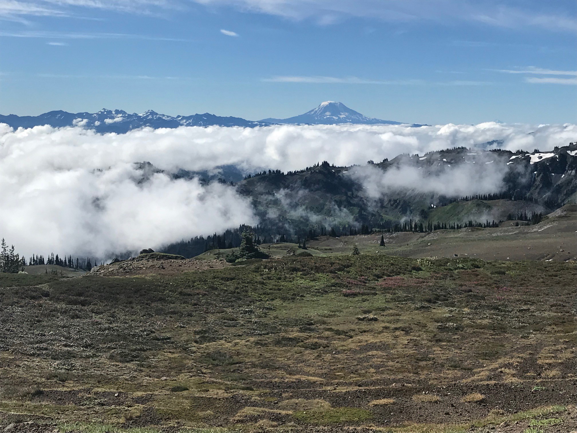


 Cascade Crest has become the ultimate quest for long distance runners in the Pacific Northwest. Nestled in the Middle Cascade mountains it offers 23,000 feet of climb and a number of special attractions like rope descents, a 2.3 mile tunnel, and a section affectionaly known as “The Trail From Hell”.


 I settled into a nice groove as we began the first climb which would last 5 miles. Again, it was a slow and easy start. We then had a nice 10 mile descent with an aid station at mile 12. The views of Tahoe were amazing as we had a picture perfect blue day. The course here is a sandier trail (I had my gaiters on) with numerous rocks of all sizes and on all sides of the trail, including the middle. I missed one turn and joined a group of others who were trying to determine if we had in fact veered up a trail instead of down another. I took out my phone and checked the Gaia GPS app and sure enough – we were looping back to the first aid station. It was only a 10-15 min mistake and we all took it in stride. The sign had fallen from its original placing which was why we had read it wrong.


 At the second checkpoint I elected to apply the moleskin and wrap both feet. Still no blisters that I could tell but I wanted to get ahead of it. This turned out to be a wise move. I immediately could tell the difference. The next section began some climbing – not brutal in a Pacific Northwest kind of way but still challenging. It was nice to get a bit of change of pace in altitude but it did throw off the consistency of walking. I found myself falling farther behind and needed to jog mall sections to catch back up. Then I would walk and fall back again. Rinse. Repeat. Of course with uphills there also were some downhills, sometimes on rocky sections. I was losing track of our next station and saw a large tent gathering over to the right. It was too soon for another checkpoint – but they had set up an Aid Station. The crew was not allowed here but we were able to rest a bit and treat our maladies. Katie had developed some huge blisters which needed attention.